
14-290 Closes in Aylestone Lane Wigston 1867.bmp

22-003 Bull Head Street Oadby Road Traffic Island 2000 Wigston.jpg

22-004 Centre of Wigston 2000.jpg

14-178 Earliest OS Map centred on All Saints Chruch.gif

14-139 Aylestone Lane Wigston Magna 1867.jpg

23-380 Wigston Magna Mediaeval Fields and Footpaths map.JPG
")
23-715 Wigston Aerial 2011 (1).pdf
23-716 Wigston Aerial 2011 (2).pdf
23-717 Wigston Line Drawing.pdf
23-718 Wigston Old 1886 (1).pdf
23-719 Wigston Old 1886 (2).pdf

26-079 David Wilson Homes Plan forNewton Lane Wigston Magna 2014.jpg

23-380a Wigston Magna Mediaeval Fields and Footpaths map.jpg

14-178b Earlist OS Map based on All Saints.psd

30-973 Wigston Reconstruction Part 1.jpg

30-871 Hoskins Map of Wigston Magna.JPG

4.32 Airforce map of Wigston Magna.jpg

4-1 Abington House April 1947.jpg

4-1a Abington House April 1947.jpg

4-1b Abington House April 1947.jpg

4-1c Abington House April 1947.jpg

4-2 Long Street Wigston Magna c 1930.jpg

4-3 Station Road Wigston Magna April 1947.jpg

4-5 Station Road and Central Avenue Ext 1947.jpg

4-6 Abington House with Central Avenue Ext in background 1947.jpg

4-6a Abington House with Central Avenue Ext in background 1947.jpg

4-7 Wigston Magna with All Saints Church in foreground.jpg

4-8 Long Street Wigston Magna.jpg

4-9 All Saints Church area Wigston Magna c 1960.jpg

4-10 Guthlaxton School Wigston Magna.jpg

4-10a Guthlaxton School Wigston Magna.jpg

4-11 Newgate End Wigston Magna pre WWII.jpg

4-12 White Gate Farm Wigston Magna.jpg

4-13 Newton Lane Wigston Magna pre 1950.jpg

4-14 Newgate End Wigston Magna 1940.jpg

4-15 Bull Head Street Wigston Magna.jpg
4-15a Bull Head Street Wigston Magna.jpg

4-16 All Saints Church and Newgate End c 1950.jpg

4-17 White Gate Farm Wigston Magna 1960's.jpg

4-18 Looking over the railway to Little Hill Estate under development.jpg

4-20 Long Street Wigston Magna 1937 taken from All Saints Church Tower.jpg

4-22 Bull Head Street & Mowsley End Wigston Magna.jpg

4-23 The Bank Wigston Magna showing Queens Head, Halls Farm and Willetts Farm.jpg
4-24 The Laundry & Johnson's Farm Yard Wigston Magna.jpg

4-24a The Laundry & Johnson's Farm Yard Wigston Magna.jpg
4-25 Long Street & Moat Street Wigston Magna.jpg

4-25a Long Street & Moat Street Wigston Magna.jpg

4-26 Kingsmead Lodge Wigston Magna before gables altered.jpg

4-27 White Gate Farm Wigston Magna.jpg

4-28 RAF picture Wigston Magna August 1945.jpg

4-29 Newton Lane Wigston Magna.jpg

4-30 Station Road Wigston Magna April 1947.jpg

4-31 Moat Street Wigston Magna.jpg

4-31a Moat Street Wigston Magna.jpg

5-15 Newgate End Wigston Magna c 1950.jpg

8-214 Newton Lane Wigston Magna 1960.jpg

8-245 All Saints and farm cluster Wigston Magna 1950.jpg

14-066 Street Plan of Wigston Magna.jpg

14-156 Bell Street Wigston map.jpg

14-156a Bell Street Wigston map copy.jpg

14-156a Bell Street Wigston map.jpg

14-158 Bulls Head Street Wigston Magna 1.jpg

14-159 Bulls Head Street Wigston Magna 2.jpg

14-160 Bushloe End.jpg

14-174 Diagram of Wigston Railways fully in place by 1872.jpg
")
14-177 Earliest OS Map centred on All Saints Chruch (2).JPG

14-178a Earlist OS Map based on All Saints.JPG

14-178b Earlist OS Map based on All Saints copy.jpg

14-179 Earliest OS Map centred on All Saints Chruch.jpg

14-179a Earliest OS Map centred on All Saints Chruch copy.jpg

14-183 Fields and Paths of Wigston Magna.jpg

14-185 FORRYAN's Courner circa 1920 by memory Leslie Forryan.jpg

14-219 Leicester Road footpath map Wigston Magna 1867.jpg

14-221 Leicester to London Railway Map.jpg

14-222 Leicestershire Railway Map.jpg

14-224 The fields of the Langham Estate Tythorn Hill Wugston.jpg

14-225 Long Street Wigston Magna.jpg

14-227 Long Street Wigston Magna.jpg

14-228 Long Street Wigston Magna 3.jpg

14-229 Long Street Wigston Magna 4.jpg

14-231 Map of Guthlaxton Hundred.jpg

14-232 Map of Wigston 1.jpg

14-240 Midland Railway Map.jpg

14-242 Moat Street Wigston Magna 1881 - 1.jpg

14-242a Moat Street Wigston Magna 1881 - 1.jpg

14-243 Moat Street Wigston Magna 1881 - 2.jpg

14-243a Moat Street Wigston Magna 1881 - 2.jpg

14-287 Google Earth view of Wigston 1.jpg

14-288 Google Earth map of Wigston 2.jpg

14-292 Wigston Harcourt Road Names Map.jpg

14-294 Wigston Magna & South Wigston Railway Map.jpg

14-295 Wigston Magna area map 1904.jpg

14-296 Medieval Footpaths of Wigston Magna map.jpg

14-300 Diagram map of Wigston Magna a ring fenced village.jpg

14-301 Wigston Magna Map 1884.jpg

14-303 Wigston Magna Town Trail Map.jpg

14-304 Wigston Parish Boundary Map.jpg

15-089 line map of Wigston Magna pre 1970.jpg

15-113 Ancient Leicester Map 1906.jpg

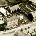
19-012 Wigston Magna from the air circa 1960.jpg

19-012a Wigston Magna from the air circa 1960.jpg

19-012b Wigston Magna from the air circa 1960.jpg

19-131 Plan of Blunt's Lane Wigston Magna 1831.jpg

19-199 White Gate Farm Newton Lane circa 1980.jpg

19-226 Map of Wigston Magna .jpg

19-226a Map of Wigston Magna.jpg

19-226b Map of Wigston Magna.jpg

19-323 Map of Wigston Magna circa 1930.jpg

19-429 Medieval Wigston Map.jpg

22-031 Oadby & Wigston District jpg.jpg

22-157 Aerial View of Long Street Wigston Magna circa 1930.jpg

22-181 Aerial view of Wigston Magna in 1947 showing new estate at the end of Central Avenue.jpg

22-303 Aerial view of All Saints' Church Wigston Magna 1950.jpg

22-316 Aerial View of Wigston, showing Abington House at the rear Central Avenue and Clarke Road 1947.jpg

22-334 Central Wigston Magna Map showing By-Pass Route Part 1 .jpg

22-335 Central Wigston Magna Map showing By-Pass Route Part 2 .jpg

22-336 Central Wigston Magna Map showing By-Pass Route Part 3 .jpg

22-337 Central Wigston Magna Map showing By-Pass Route Part 4 .jpg

22-473 Route of Wigston Magna By-pass 1968 .jpg

23-026 1930's Aerial view of All Saints' Church Wigston Magna.jpg

23-027 View from All Saints' Church looking towards the Laundry with chimney in the distance - Wigston Magna.jpg

23-028 View from All Saints' Church looking towards Welford Road across top of Newgate End - Wigston Magna.jpg

23-057 Map showing land by Spion Kop sold to the Midland Railway Company.jpg

23-368 Wigston Railway map c 1905.jpg

23-380b Wigston Magna Mediaeval Fields and Footpaths map.jpg

23-380c Wigston Magna Mediaeval Fields and Footpaths map.jpg

23-381 Newgate End Freehold Property Map.JPG

23-383 Leicestershire Railways built since 1832.JPG

23-384 Leicestershire Railways built since 1832.JPG

23-387 Wigston Map 1886 -1888.jpg

23-388 plan of South Leicestershire College Station Road Wigston Magnacirca 2000.jpg

23-389 Plan of Fire Station and Police Station on Bull Head Street Wigston Magna circa 2000.jpg

23-390 Plan of Spa Lane Wigston Magna circa 2000.jpg

23-391 Plan of Library and St Wistans Church Bull Head Street Wigston Magna circa 2000.jpg

23-392 Plan of The Grange Wigston Magna circa 2000.jpg

23-393 Plan of All Saints Church and Moat Street Wigston Magna circa 2000.jpg

23-394 Plan of The Plough in Bushloe End Wigston Magna circa 2000.jpg

23-395 Plan of the Co-op building in Long Street Wigston Magna circa 2000.jpg

23-396 Plan of the Co-op building and warehouse in Bell Street Wigston Magna circa 2000.jpg

23-397 Plan of the Council Office in Station Road Wigston Magna circa 2000.jpg

23-429 Wigston Map in the Middle Ages.jpg

23-443 Map showing All Saints Church Wigston Magna.JPG

23-445 Map of Wigston Railway Junction.JPG

23-446 Map showing Ministy of Supply Cold Store during WWII.JPG

23-660 Wigston Aerial view Bell Street and Leicester Road c 2000.jpg

23-662 Map showing the medieval streets of the the village of Wigston Magna.jpg

23-662a Map showing the medieval streets of the the village of Wigston Magna.jpg

23-662b Map showing the medieval streets of the the village of Wigston Magna.jpg

23-764 Location of Two Steeples factory in Wigston Magna 1930.jpg

23-765 Aerial view of Cromwell Tools in 2004 prior to demolition.jpg

25-042 Aerial photograph of Wigston Magna 1945.jpeg

26-078 David Wilson Homes Plan forNewton Lane Wigston Magna 2014.jpg

26-080 David Wilson Homes Plan forNewton Lane Wigston Magna 2014.jpg

26-081 David Wilson Homes Plan forNewton Lane Wigston Magna 2014.jpg

26-090 Constitutional Hall Cross Street Wigston Magna.jpg

26-098 Wigston Magna line drawing 2014.jpg

26-130 Wigston Map circa 1948.jpg

26-137 Moat Street 1950 taken from top of All Saints Church.jpg

26-324 Land use in Leicestershire 1969.jpg

26-327 Leicestershire Nodal Structure 1950.jpg

26-359 Position of Wigston in Leicestershire.jpg

26-360 Proposed by-pass and traffic flow system for Wigston Magna circa 1960.jpg

26-363 Services in Wigston Magna in 1960.jpg

26-368 Wigston Magna Map circa 1965.jpg

26-496 Map of Kilbridge Area.JPG

29-040 Picture of site of the old Wigston Magna Station.JPG

29-060 Kilby Bridge two chain plan 1902.JPG

29-061 Kilby Bridge original railway drawings from 1902.jpg

29-062 Kilby Bridge original railway drawings from 1902.jpg

29-063 Kilby Bridge original railway drawings from 1902 showing siding to quarry.jpg

29-064 Rail Link to Lime and gravelquarry at Kilby Bridge circa 1905.JPG

29-069 pre 1902 track layout at Kilby Railway Bridge.JPG

29-070 post 1902 track layout at Kilby Railway Bridge.JPG

29-077 1886 OS Map of Wigston Cemetery Welford Road.JPG

29-077a 1886 OS Map of Wigston Cemetery Welford Road.jpg

29-078 1886 OS Map of Newgate End Wigston Magna.JPG

29-079 1886 OS Map of Bushloe End Wigston Magna.JPG

29-080 1886 OS Map of Station Road Wigston Magna.JPG

29-080b 1886 OS Map of Station Road Wigston Magna.jpg

29-081 1886 OS Map of Station Road Wigston Magna.JPG

29-082 1886 OS Map of Welford Road Wigston Magna.JPG

29-083 1886 OS Map of The Bank Wigston Magna.JPG

29-084 1886 OS Map of Newton Lane and Welford Road Wigston Magna.JPG

29-085 1886 OS Map Moat Street Wigston Magna.JPG

29-086 1886 OS Map of Leicester Road and Bell Street Wigston Magna.JPG

29-087 1886 OS Map of Burgess Street Wigston Magna.JPG

29-088 1886 OS Map of St Wolstan's Church and Oadby Lane Wigston Magna.JPG

29-089 1886 OS Map of The Bank Wigston Magna.JPG

29-090 1886 OS Map of Station Road Wigston Magna.JPG

29-359 All Saints Church and Newgate End.jpg

29-363 Plan of Station Road showing land owners.jpg

29-366 Wigston Magna 1967 prior to widening of Bull Head Street.jpg

29-413 Junction Road Wigston Magna.JPG

29-567 1881 Map of Wigston Magna and Kilby Bridge.JPG

29-620 Map of Wigston Magna circa 1990.JPG

29-621 Map of Wigston Magna circa 1990.JPG

29-622 Map of Wigston Magna circa 1990.JPG

29-623 Map of Wigston Magna circa 1990.JPG

29-624 Map of Wigston Magna circa 1990.JPG

29-625 Map of Wigston Magna circa 1990.JPG

29-626 Map of Wigston Magna circa 1990.JPG

29-627 Map of Wigston Magna circa 1990.JPG

30-081 View of the Mile Straight at the Race Cource taken from the Tower of St Wistan's church circa1956.JPG

30-240 Bushloe End from the air.JPG

30-247 Tythorn Hill Map.jpg

30-519 Old map showing the location of Wigston.JPG

30-818 LRO Wigston Magna from the air 2016.JPG

30-819 LRO Wigston Magna from the air 2016.JPG

30-823 Map of old Wigston Village.JPG

30-824 Medieval period was from the years 1042 to 1377.JPG

30-829 Wigston Magna from the air about 1930.JPG

30-841 Aerial view of Long Street Wigston Magna circa 1950.JPG

30-861 Albert Hill factory location with two entrances..JPG

30-873 Map of Wigston Magna reconstructed circa 1140 AD.jpg

30-874 Map of Wigston Magna reconstructed circa 1850 AD.jpg

30-884 Location of the old oak boundary tree just below the D.JPG

30-891 Map of Wigston Magna circa 1942.JPG

30-898 Position of Wigston in Leicestershire.jpg

30-911 Rectory Farm behind All Saints church Wigston Magna.JPG

30-954 Three Fields of Wigston.jpg

30-956 UK Map.JPG

30-962 Map of Wigston Magna reconstructed circa 1500 AD.jpg

30-969 Wigston Magna from the air 2016.JPG

30-972 Wigston Map.JPG

30-974 Wigston Reconstruction Part 1b.jpg

30-975 Wigston Reconstruction Part 2.jpg

30-976 Wigston Reconstruction Part 2b.jpg

30-977 Wigston Reconstruction Part 3.jpg

30-978 Wigston Reconstruction Part 3b.jpg

31-134 Wigston Magna 1960's Map.JPG

31-146 looking across Leicester Racecourse towards Wigston, 1952.JPG

31-212 Magna Map showing Football grounds 1914.JPG

31-281 Workhouse Lane location Wigston Magna.JPG

31-294 Mill Lane Wigston Magna Map 1886.JPG

31-295 Frederick Street Wigston Magna Map 1930.JPG

32-261 All Saints Church and Newgate End Wigston Magna.JPG

32-338 Wigston Magna from the air circa 1960.JPG

32- 356 Location Map of Wigston Magna.JPG

32-357 Map of Wigston Magna circa 1990.JPG

32-358 Map of Wigston Magna circa 1990.JPG

32-359 Map of Wigston Magna circa 1990.JPG

32-391 Wigston, 1952. Photo taken from the north, above the racecourse.JPG

32-394 Aerial View Wigston Magna 1930.jpg
")
23-718 Wigston Old 1886 (1).jpg
